Chiniak Alaska Chiniak stuff
 Bear safety · Alaska Dept. of Fish & Game ↗
Useful Information
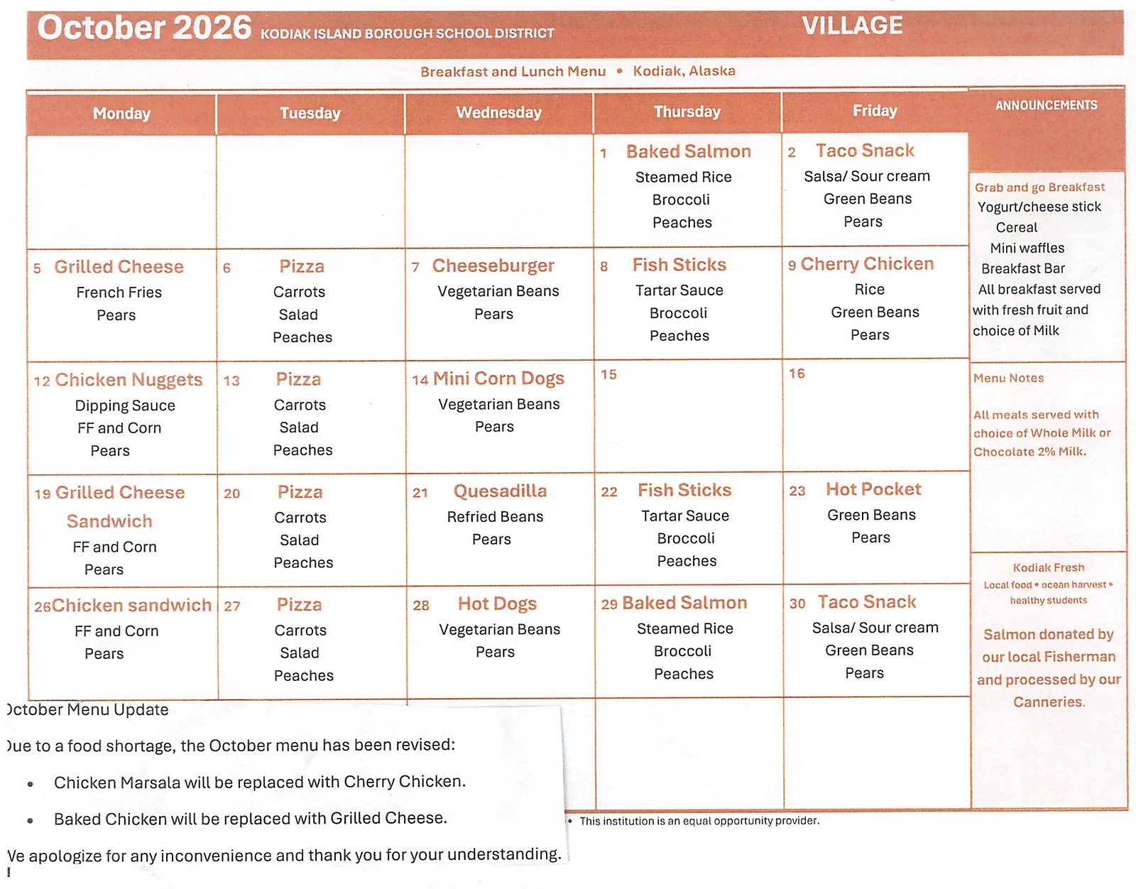
School Lunch Menu
October 2026 · Chiniak School
Chiniak School breakfast and lunch menu, from the Kodiak Island Borough School District.
Click on the district menus link if this PDF is not updated.
School District Calendar
School Board Meetings & Addenda
Agendas, minutes and meeting packets on BoardBook, including Chiniak Advisory School Board minutes.
Open meetings & addendameetings.boardbook.orgAround Chiniak
Chiniak Library
Website to come soon.

Chiniak Post Office

907-486-0838
36158 CHINIAK HWY
CHINIAK, AK 99615 – 9801
- MonClosed
- Tue04:00 PM – 06:00 PM
- WedClosed
- Thu04:00 PM – 06:00 PM
- FriClosed
- Sat12:00 PM – 02:00 PM
- SunClosed
Chiniak Hwy Roadwork
DOT’s draft 2027–2030 plan
Here’s where and when Alaska DOT&PF plans to work on the Chiniak Highway, from its draft 2027–2030 plan and its Milepost 15 to 31 project. The numbers on the map match the list. Tap the map to see it full size.
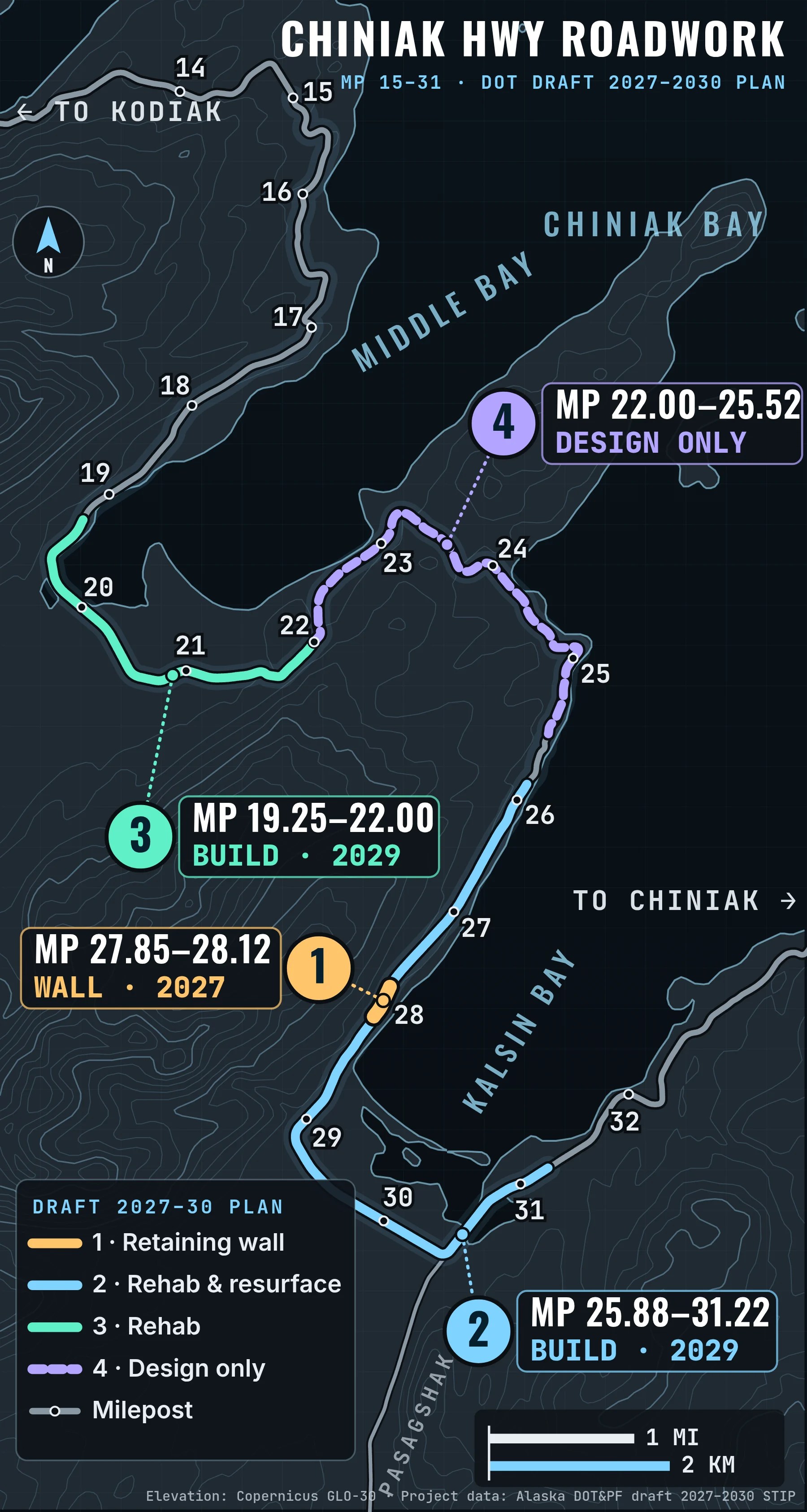
- Retaining wall at Kalsin Bay MP 27.85–28.12 · Construction 2027 · $11.8M A soldier-pile retaining wall to stabilize a vulnerable stretch of road on the Kalsin Bay side. DOT’s preliminary plans call for flaggers and one-lane traffic during lane closures. Preliminary plans (PDF)dot.alaska.gov
- Rehab and resurfacing around Kalsin Bay MP 25.88–31.22 · Construction 2029 · $17.0M Rebuilds the roadbed and repaves this whole stretch, with new drainage and culverts, guardrail, lighting, signs and striping. The wall in project 1 is done separately first. DOT project page (MP 15–31)dot.alaska.gov
- Rehab at the head of Middle Bay MP 19.25–22.00 · Design 2027–2028 · Construction 2029 · $18.44M Rebuilds the deteriorated pavement and roadbed, and fixes drainage, culverts, guardrail, lighting, signs and striping as needed. Right-of-way (land) work is planned for 2028. Draft 2027–2030 plan (PDF, 38 MB)dot.alaska.gov
- Middle Bay to the Kalsin Bay side (design only) MP 22.00–25.52 · Design 2029–2030 · No construction in this plan Rehab and repaving are planned here, but this plan only pays for design and land work ($2.58M). DOT lists another $17M for 2031 or later. Comment on the draft plan (until Oct 29, 2026)dot.alaska.gov
Years are federal fiscal years, which run October to September, and this is still a draft, so dates and dollars can change. The map places each project using DOT’s milepost signs, so positions are close but not survey-exact.
Comment on the draft 2027–2030 plan (until Oct 29, 2026)dot.alaska.gov DOT project page: Chiniak Hwy MP 15–31dot.alaska.gov Road conditions and delays (511)511.alaska.govSee what Kodiak Maps can do
Real screens from the app. Tap one to see it bigger, or swipe for more.
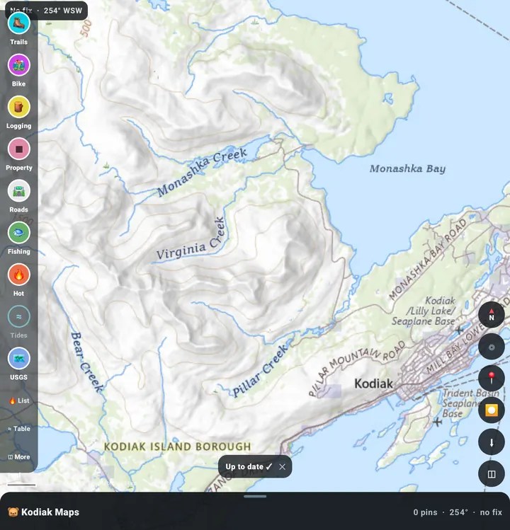
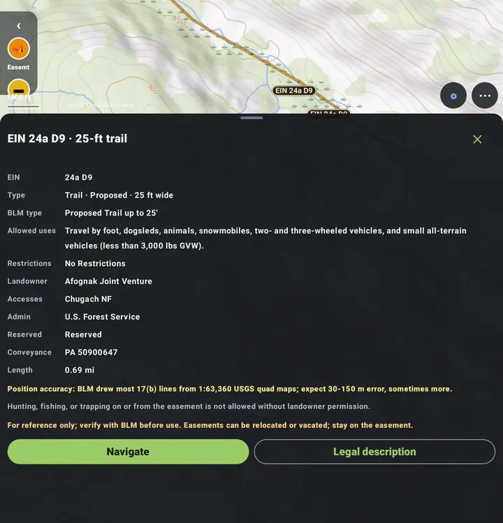
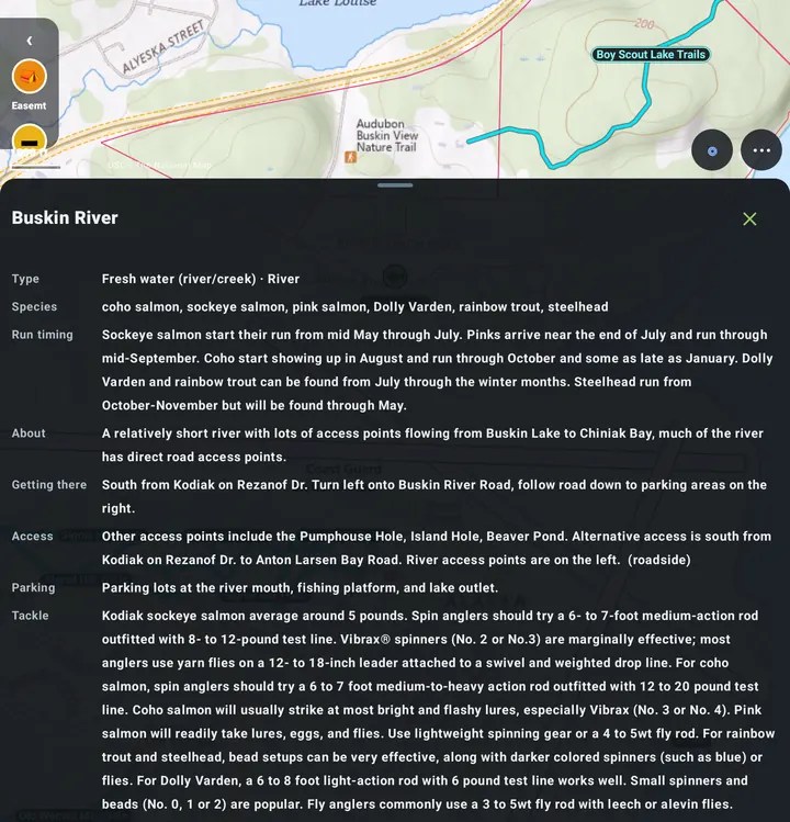
- 17(b) easements. Tap one to see if it is a trail or road and who can use it: foot, ATV, snowmachine.
- Trails and roads. Kodiak trails, the town bike trails and the Chiniak logging roads.
- Fishing and tides. ADF&G fishing spots with species and run timing, plus NOAA tide tables.
- Places. Food, travel, schools, the Chiniak Library and military history. The military layer now shows buildings from the old 1965 Navy maps, with info cards.
- Works with no signal. All Kodiak layers are built in. Save topo map areas on Wi-Fi for offline use.
- Private and simple. No accounts, ads or trackers. A short guided tour shows you around.

Free offline map of Kodiak Island
Made for Kodiak: 17(b) easements, trails, the Chiniak logging roads, schools, the library and topo maps, plus old Navy buildings with info cards in the military history layer, all working with no cell signal. Android app, version 1.5.15.
Local Businesses


Kayak Kodiak
- 907-512-5112
- info@kayakingkodiak.com
- 1231 Mill Bay Road
Kodiak, Alaska


Chiniak on Kodiak Maps
The full Kodiak Maps web map, free in your browser. It opens on Chiniak with the logging roads, 17(b) easements and military history sites turned on. From there you can move around all of Kodiak Island, switch base maps and turn on trails, fishing spots, road names, land ownership and more.
Works on phones and computers. Nothing to install.
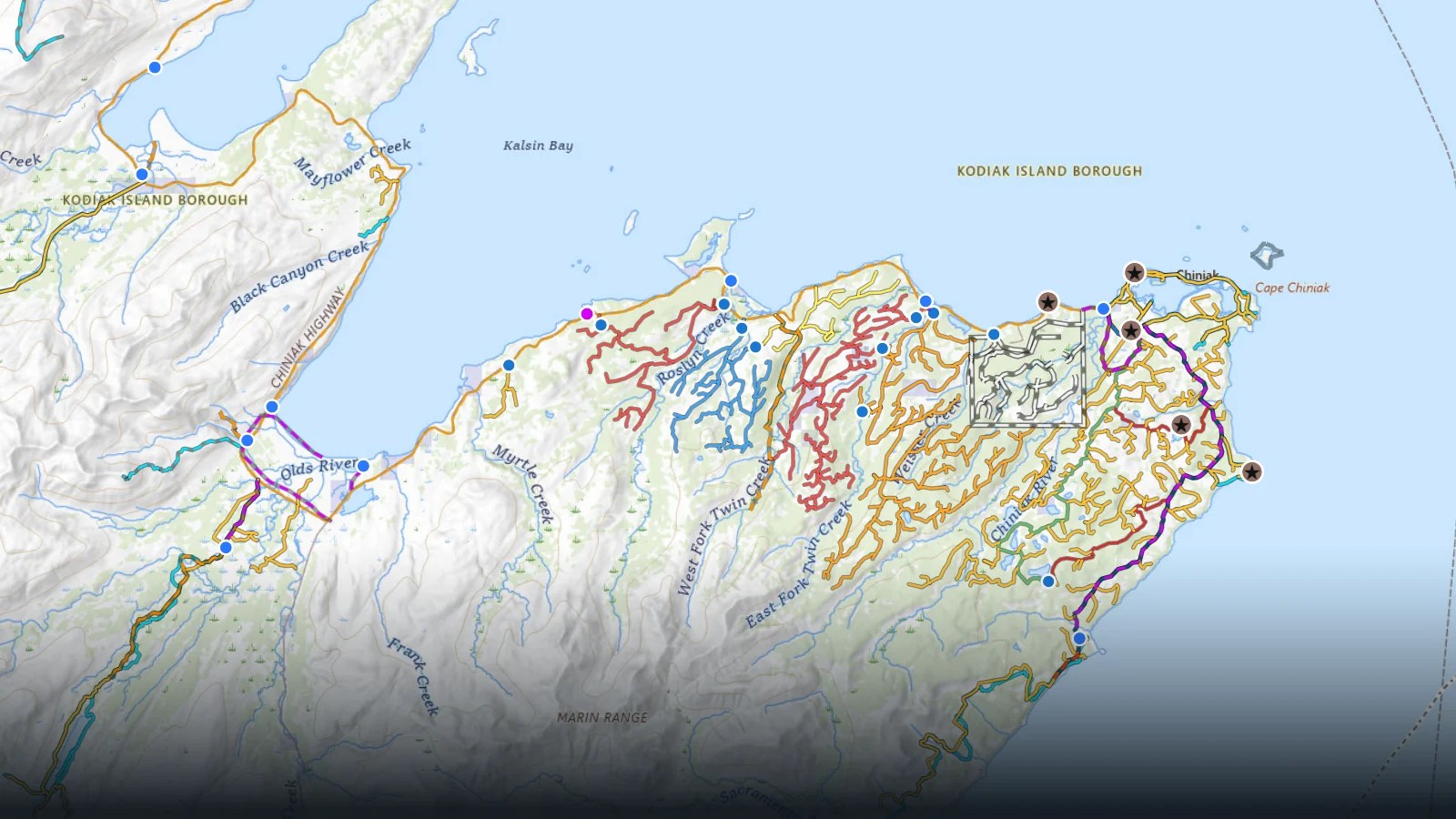
Chiniak logging roads
Logging roads I mapped, with the 17(b) easements and military history sites, on the USGS topo. Open the full map →
17B Easements
It is important to understand land use rights with 17(b) easements. Remember to always respect land owners but do not let them tell you that you are not allowed to be there, or that it is by permit only. Read the easement details below to find what is allowed.
leisnoi Land and easement details
Woman’s Bay,Middle Bay,kalson Bay Easements
ANCSA 17(b) easements are rights reserved to the United States in accordance with 43 CFR 2650.4-7 Public easements. They are reserved to provide access to public lands or major waterways. Most often, these reservations are transportation easements including: 60-foot wide existing roads, 100-foot wide proposed roads, and 25- and 50-foot existing and proposed trails. Site easements and miscellaneous easement may include aircraft landings, vehicle parking, temporary camping, and loading and unloading areas. These rights are reserved when the BLM conveys land to a Native corporation under the Alaska Native Claims Settlement Act (ANCSA).
Easement Terms of Use
The uses allowed for a one (I) acre site easement are: vehicle parking (e.g., aircraft, boats, ATVs, snowmobiles, cars, trucks), temporary camping, and loading or unloading. Temporary camping, loading, or unloading shall be limited to 24 hours.
The uses allowed on a sixty (66) foot wide road easement are: travel by foot, dogsleds, animals, snowmobiles, two- and three-wheel vehicles, small and large all-terrain vehicles {ATVs), track vehicles, four-wheel drive vehicles, automobiles, and trucks.
The uses allowed on a twenty-five (25) foot wide trail easement are: travel by foot, dogsleds, animals, snowmobiles, two- and three-wheel vehicles, and small all-terrain vehicles (ATVs) (less than 3,000 lbs. Gross Vehicle Weight (GVW))
The uses allowed on a fifty (50) foot wide trail easement are: travel by foot, dogsleds, animals, snowmobiles, two- and three-wheel vehicles, small and large all-terrain vehicles (ATVs), track vehicles and four-wheel drive vehicles
Chiniak logging roads
Below is a map of the logging roads in Chiniak that I am working on. I will update here when it is finished

Chiniak records
Chiniak Comprehensive-Plan 1987
Some cool videos I found on YouTube
Silver Beach
Chiniak Pt.


